|
|
|
|
|
25-26th Jan 2004 This trek-cum-rock climbing is a unique one for Bhramanti. No doubt it is called RDE 2004 (Republic Day Exploration 2004) or should I say Expedition! The climbing team comprising of Rajan, Milind, Harshal, Kaivalya, Kiran, Mahindra…..and myself met at Rajan’s house at Borivali at 11.30 pm on Saturday, 24th January. …And I were actually a part of the treks. At the same time the trekking team comprising of Dinesh, Soloman, Tejas and Gopal met at Dadar. They were accompanied by Deepak, who had come for expert guidance to the rock-climbers. Deepak had climbed both the pinnacles, which was intended to be climbed by Rajan and his team. We started with the Tata Sumo driven by Somnath, at 12.30am on sunday morning, 25th January. We took the Ghodbundar road to Thane and then on the Agra road towards Nasik (National Highway No. 3). After reaching Nasik we turned towards Trymbakeshwar (One of the 12 Jyotirlingas of India). We reached Pahine base village at 6.45am. After deciding where we are going to camp we left the sumo along with myself to Nasik CBS. The trekking team was already waiting for us there. They had a bit of problem in boarding the bus but nevertheless they reached safe and sound. What more do you want? There are always ups and downs in life! After picking up the guys the entire Bhramanti group of 13 members finally met at Pahine at 8am. Meanwhile the Nashik Team Chetan, Bhushan & co reached there to join us. After breakfast the two groups separated out wishing luck to each other. The trekkers were to climb Harihar and the climbers Pahine-Navra and Navri.
We climbed to the col between Fani dongar (3255 feet) on the left and Harihar to the right. The pinnacle of Fani, which is about 30 metres high resembles the hood of a cobra. Hood means ‘fan’ in Marathi and hence the name. From the col we turned right towards the fort. On the way we met Alok, an experienced trekker who was accompanied by his brother and a friend. After a brief chat with him we moved on. They were suppose to camp on the fort. A short walk from here through overgrown trees brings us to the base of the rock-cut steps. The steps are very steep. But there are niches on each step for gripping. Climbing up we passed through the first gate of the fort. From here we walked under an overhang to reach a few more. From here on the steps are winding and we finally reached the top passing through the second gate. Walking a little ahead we saw a small Hanuman temple with a pond behind it. On the right we see the small hump of the fort which is actually very small. We decided to tackle this later and walked further on. Here there was another temple with a cave, but without a deity. This is a good place for overnight camping. The view from top is very exciting. One can see Vaghera in the north, Tringalwadi, Kavnai and Upper Vaitarna lake in the south, Brahma, Kapda and Brahmagiri in the east, and Fani, Basgad and Utwad in the west. Finally we climbed the actual top. A bit of easy rock-climbing is required to be done without equipment. We descended the hump and had our lunch besides the pond. After a bit of rest we started descending at 3.30pm. We reached the base at 5pm and took our sumo back to our actual base at Pahine. This was indeed a memorable trek for the six of us. -- Ruzbeh. Billimoria. |
|
Prelude
26/1/04 Unfortunately the next day we all woke up around 7am. We made our breakfast and the climbing team left by around 9am to complete their tough climb of Pahine Navra Pinnacle. The trekking team now comprising of 5 members only [Tejas, Solomon, Gopal, Narhari & Myself] (Ruzbeh decided to go with the Climbers as a support member) left Pahine by Sumo by around 9.30am. We were supported by Gangadwar & Trimbak, the two local boys from Pahine Village who would be guiding us to Anjaneri. From Pahine Village we cameback to the main road (trimbak to Khodala - Goti) and turned right and took the main Nasik - Trimbak highway. We turned right and proceeded towards Nasik. We could see the Anjaneri hill on the right side from this point. We drove for about 1.5 km and turned right towards Anjaneri Village. At this junction there is a small temple and also a signboard stating "Anjaneri - Birthplace of Lord Hanuman". From here the road climbs past Anjaneri Village upto the first plateau of the fort. Earlier one had to climb from a cart track before the village but now a road is coming up right upto the first plateau. On the way we can see the Anjaneri Navra pinnacle on the left side. On the first plateau there is a large banyan tree with a nice resting place. We parked our sumo there and to our surprise, Somnath our driver also decided to come along. The more the merrier! Just behind the tree one can find broken steps leading to the top. Further down the steps disappear and the route (quite visible) goes zig-zag until it reaches a rock massif which one has to traverse. This is a rocky path with exposure on one side and one has to carefully cross the same. We then reach a set of steps (recently constructed), which climbs into a Col. (gully) between the range. Earlier there were huge boulders but now steps have been made so that people can visit the Anjana Mata Temple at Anjaneri. On the way we find a small cave with some Jain statues in it. The steps end on the second plateau and we walk on this huge plateau and reach a temple. This is the Anjana Mata Temple (mother of Lord Hanuman) with the statues of the Devi and Lord Hanuman in it. We all take rest for sometime. It been about 45min that we have started climbing but nobody seems to be exhausted as the climate has been generally cool. After spending about 10min at the temple we proceed towards the final plateau from behind the temple. A few yards ahead we find a huge water tank (one can say a small lake). This sight brought in great relief amongst us and everyone decided that on our way back we need to have a bath (since our last bath was on 24th Jan). As we passed the lake we arrived at some steps climbing upwards and with the help of railings (for support at various places) we reached the top of the Hill. It took us 1.5 hrs to reach the final plateau from the base (where the sumo was parked). The view from here is excellent, one can see the Nasik - Trimbak road, the upper Vaitarna lake in a distance, Brahmagiri Hills, Dangya etc. We walked for about 10-15 min and arrive at the temple of Lord Hanuman. It's a beautiful temple and is regularly attended by a Pujari and his family from Anjaneri village. We took some photographs, explored the area, rested for a while and then came down the same way. After reaching the water tank we turned right into the forest toward Sitecha Gumpha (Sita Caves). These caves are dug out from a rock wall and have some statues in it. There is also an ashram next to the caves. An old sage has been living here for many years. We returned back to the water tank and all of jumped into the water. The water was extremely cold and our bones started paining. Tejas started shivering before even entering the water…What a sight! Anyway we were all there in the water holding hands - Narhari, myself, Solomon and taking dips turn by turn as there was lot of slush in the water and it was not so easy to stand. After drying ourselves we took rest nearby & finished all the food we had brought along. It was already 1:30pm and we had to reach Nasik by 3pm. We returned to the base (first plateau) by around 2:30pm (where we had parked our sumo). After refreshing ourselves with lime juice (sold by a local villager) we set out for Nasik. We reached Nasik - Mahamarg Depot by 3:15pm and found a huge crowd waiting for Bombay buses. The Sumo alongwith the two boys (guides) returned back to Pahine to bring back the climbing team. We waited till 5pm for our bus and reached Sion by around 9:30pm and subsequently everyone reached home by around 11pm. Whilst returning we all realized that it was our republic day and none of us thought about flag hoisting and singing the national anthem but as per the name suggested by Rajan They did host the flag on the Pahine Navara Summit 2:13pm. They didn't sing the National Anthem due to the time (supposed to be 8:00am). It was a good sign for Bhramanti. We were all in very high spirits for taking part in Bhramanti's Republic Day Exploration Trek - 2004, a part of which was climbing the tough Harihar Fort. P.S. : Our local guides told us that the route which we had taken is quite a common route and next time we have to climb upto Anjaneri from Pahine Village. This would be somewhat steep and good climb. Must attempt it next time…. -- Dinesh Nair |
|
25-26 Jan 2004 On 25th Jan Early morning we all reached Pahine. Another team from Nashik joined us at pahine. It took one hr. to reach the base of the Paine Navara-Navari Pinnacle from the Village. We had planned to divide the team in two & attempt both the pinnacles. I was the lead climber for the Navara & Kaivalya was leading Navari. The Navara team members were Harshal, Kiran, Milind while Navari team members were Bhushan, Chetan both from Nashik.
On the Navara face first 30 ft climb is free climb where one can anchor the rope to the small tree. The next 20 ft free climb & then the critical upward traverse on right side ascending till the first ledge. The small ledge on the traverse one has to take care a lot since it has little overhang. Previous climbers (Chetan from Nashik) has bolted a peg on the traverse on the foot hold of the traverse where one can fixed the rope for anchoring. On the ledge one person can stand comfortably. I asked the second man to come up till this ledge & support me for further climb. Due to some rope management problem Harshal has to climbed down & re-climb till the ledge where I was waiting for the second man support. It was almost wastage of 90 min. in the process which drained us unnecessarily. Later the overhang patch was too much for me & requested Harshal to Lead the overhang patch thinking his height will be an added advantage. Though Harshal climbed the patch we were too much tired in the process. Also Milind came to the ledge where we reached to support us by 4:30pm. Kaivalya too was supporting us from the Navari's col face. Finally I decided to move down & try the next day with fresh mind & energy. We return back to the Base at Pahine village for the rest. The trekking team yet had not been reached from the Harihar
fort due to problem with our vehicle (Sumo). The next day 26th Jan 2004 by 9:30am we all were at the base of the pinnacle. We reached till the last climbed patch by zoomarring. Then proceeded further climb. The first climb was critical where we were supposed to do the traverse. IT took time but due to support of kV I could able to do it where a good condition bolt exist. Further climb of another 30 ft towards right was easy. Another bolt one can find on this patch where 2 person can stand comfortably. Here lies the last difficult patch. I called the second man kV till this ledge to support me further climb. The overhang over here was too much for me. I tried using eterrior first then tried to climb on KV's sholder (like Dahihandi) to get hold of another rock hold which also was unsuccessful. AT one time I thought of give up & asked KV to tackle this patch but kV support me to fight. So with help of etterior & back support from KV I could able to reached a small tree firm base. From here the rock patch of 10 feet one has to pull his/her body against the exposure at back side. While doing this move unfortunately One of the left rock hand hold came out & I could able to manage the situation. But the moment when the rock hand hold came out I was in tense mood & till I get the proper foot hold. I spent some time to relax from this situation & then moved further tackling from the cactus & loose scree till the summate. It was 2:13pm exactly I was on top. As per my watch the height shown here is 3140ft. I spent almost 90 min alone on the summate waiting for other members to greet me & vice versa. IT was my seventh experience. Kiran & Milind's Second experience. It was Republic Day Exploration 2004. I did opened up the Tricolor on the summate to salute in a different manner. By 4:30pm all were on top. Since it was late we could not able to finish the windup in time. kV & Milind were on the face till dark where the child wind were making the rock cold & also the climbers. Fortunately we were equipped with head torch by which Kaivalya did manage to rappel down successfully with Milind. It was new experience for Milind but usual to kV The wind up exercise happened by 9:00pm. The rest of the team had already sent down to complete further movement at our base. It was a grate help from Nashik team specially Bushan on that day to help us for wind up. We reached the base by 10:00pm. Sorted the equipment & return back to Mumbai the next day via Ghoti road. I am verymuch thankful to Rajesh Gadgil & Sahyagiri for the equipment as well Nandu Chavan for the timely help for the equipment help. -- Rajan |
|
|
 About
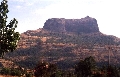
Harihar: The trekking group left by sumo to Nirgudpada, the base
village of Harihar (3676 feet above mean sea level). The leader of this
trek was myself and the deputy was Dinesh. We reached the base by
10.45am and started trekking by 11. As mentioned by Harish Kapadia in
his book, this fort is indeed built on a triangular prism of rock. Its
three faces and two edges are absolutely vertical (90 degrees). The
third edge towards the west is inclined at an angle of 75 degrees. A
one metre wide rocky staircase with niches is carved out for
ascending/descending the fort. Unique construction, isn’t it? One of
the faces facing Nirgudpada is called ‘Scottish kada’, perhaps because
it was climbed for the first time in November 1986 by Doug Scott, a
British mountaineer. This cliff (‘kada’ is the Marathi word for cliff)
is about 170 meters in height. Looking at the cliff from our angle
gives one a gulp down the throat! It so amazing to imagine that someone
has actually climbed the cliff. Difficult to digest, but very
fascinating.
About
Harihar: The trekking group left by sumo to Nirgudpada, the base
village of Harihar (3676 feet above mean sea level). The leader of this
trek was myself and the deputy was Dinesh. We reached the base by
10.45am and started trekking by 11. As mentioned by Harish Kapadia in
his book, this fort is indeed built on a triangular prism of rock. Its
three faces and two edges are absolutely vertical (90 degrees). The
third edge towards the west is inclined at an angle of 75 degrees. A
one metre wide rocky staircase with niches is carved out for
ascending/descending the fort. Unique construction, isn’t it? One of
the faces facing Nirgudpada is called ‘Scottish kada’, perhaps because
it was climbed for the first time in November 1986 by Doug Scott, a
British mountaineer. This cliff (‘kada’ is the Marathi word for cliff)
is about 170 meters in height. Looking at the cliff from our angle
gives one a gulp down the throat! It so amazing to imagine that someone
has actually climbed the cliff. Difficult to digest, but very
fascinating. 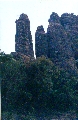 Navari climbing started first then the Navara. Deepak was
the Climbing Manager for Navara. We started Navara climb at around
12:15pm from the col of Navara-Navari while Navari climbing starts from
the col between Navari & connect pinnacle Sasra. It was one of the
unique experience to climb Navari using the bridging technique till the
choke stone & difficult climb further. The bolt/peg/pitton
condition at Navari is worst. Both Bhushan & Kaivalya explored the
route till choke stone alternatively tackling the bridging as well the
scree face. They climbed the half way & decided to return back to
help Navara team to make it success. But unfortunately it didn't
happened & The Navara team also return back from the half way
hoping for the best on the next day that is 26th Jan.
Navari climbing started first then the Navara. Deepak was
the Climbing Manager for Navara. We started Navara climb at around
12:15pm from the col of Navara-Navari while Navari climbing starts from
the col between Navari & connect pinnacle Sasra. It was one of the
unique experience to climb Navari using the bridging technique till the
choke stone & difficult climb further. The bolt/peg/pitton
condition at Navari is worst. Both Bhushan & Kaivalya explored the
route till choke stone alternatively tackling the bridging as well the
scree face. They climbed the half way & decided to return back to
help Navara team to make it success. But unfortunately it didn't
happened & The Navara team also return back from the half way
hoping for the best on the next day that is 26th Jan.