|
|
|
|
|
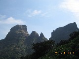
Region : Igatpuri Kulang… it offer ones the longest and heighest climb from the base to the top amongst any other fort in the Sahayadris. Standing at the height of 4822 ft, it also boasts about one of the finest views form the top and is graded as a medium / difficult trek. Accompanied by other 9 participants and as per to the decided schedule we started off from Thane at around 11pm. We took the ST bus to Nashik, which would take us via. Igatpuri / Ghoti where we had to alight for our further journey. The journey was a merry 4 hrs drive, short and sweet as we all slept our way through. Lucky enough, we were able to alight at Ghoti, rather than getting down at Igatpuri and making our way to Ghoti which the distance in-between is approximately 3-4 kms. The long midnight wait finally ended up in disappointment when we came to know that there was no such bus in the morning at 6am heading to Ambewadi. In fact the bus in the morning for would leave at 10am. Without waiting any longer at the bus depot, we immediately made our way to the “Bhandardara Phata” a junction away at a distance of 20 min from where we were sure enough to get a jeep or atleast tempo to Ambewadi which is at a distance of 27 kms from Ghoti. It was 6.40 am by now and the long wait for this mode of transport made all others extremely impatient. Ghoti being a center place, a huge local market takes place on Saturdays and being unlucky enough we would have to wait long for the jeeps or tempos which would return only on selling off all at the market what they had brought. The only option left now was to hire a separate jeep right upto Ambewadi. This option would certainly run us out of our budget. It was cold, time was running out, there was no other alternative at those early hours, but to go in for it. Finally, after waiting very long for almost an hour, we managed to find a jeep. We had to pay a little extra for this transport, but it was worth it. Squeezing ourselves along with our sacks into the vehicle we finally moved out of the place towards our base village “Ambewadi” from where reaching the base of Kulang would take us another one hour. There is another alternative route to Kulang. From Igatpuri one has to reach ‘Bahuli’ village from where, walking, it takes 3 to 4 hrs to reach Kurangwadi and from kurangwadi to base of kulang another hour. The route we took was much shorter, though we had to wait long at the junction. Its anytime better than walking from Bahuli village for 3-4 hrs with those heavy sacks and then climbing Kulang for another agonizing 7 hours. “No Way!”. Drive to Ambewadi was fun. The early morning rays of the sun greeted us. Making our way through the winding roads running up and down with mountains on either sides we finally reached Ambewadi at 8.30 am where our joy-able journey ended and the trek started. Ambewadi is small but a very beautiful, clean and a picturesque village having Kalsubai range (Kalsubai - heighest peak) standing tall on one side with the mighty Adan, Madan and Kulang on the other. There are innumerous prominent cattle trails leading into forest in various directions, due to which finding the correct path is difficult. With the fear of getting lost and wasting time and energy in finding the correct trail leading to base, we decide to hire a villager who would guide us on the correct trail right upto the top. After equal distribution of weight of food stuff and other material we were carrying, we started our trek at around 9 am. The initial walk was over a cart trail across the flat plateau. Kulang stands right in front of us with Chota Kulang adjacent to it on its right. Making our way through the dense and thorny undergrowth we cross a river bed which runs dry except for the monsoons. From here onwards the path climbs up gradually and no sooner comes across a waterfall. We rest here for a while and move on. Here the path takes a 90 degree turn towards the left, skirts the mountain slopes and heads to Madangad. We don’t take this path. Instead continue on the path towards the right which climbs upwards. In another 15-20 mins the route gets into a gully from where the steep climb begins. It roughly takes an hour and a half from the village to reach this place. From here on a well trodden trail heads towards the top. The path is winding and is over the loose mud through the tall grown vegetation. After climbing through the forest for about an hour from the waterfall, we come into an open flat ground. Keeping the vertical wall of Kulang on the left and Madangad exactly behind, we walk over the flat ground, which, further starts ascending slightly with the valley on the right. Walking for about 20 min, we reach the other end. From here onwards we climb the upper section of the ridge. On the way up, towards the left, we come across patches of rock cut steps. The climb gets steeper and tiring. Climbing for about 15 min, the final rock patch with rock cut steps leading to the top comes into view. We rest here for awhile. Recollecting our breath, we move ahead to climb the final stretch of our trek. Climb is steep, narrow with enough exposure on one hand, also
at places few steps have crumbled down. This After a mild exploration of the fort, we return back to the
caves for the night stay. It took us almost seven hours to reach this
place form the base village Ambewadi. The hot soup was the most
welcomed treat to all after the long exhausting climb. Sitting on the
rocks out side the cave, we all enjoyed the sunset sipping the hot
soup. The cave is cozy enough to shelter one from the cold chilly
night. Having had our dinner ‘The Khichadi’, which KK and Mukthesh
prepared we soon winded up for the day. Poha and tea along with biscuits were on breakfast menu.
Freshened by the cold waters from the cisterns, we relished on the
poha. Explored the other end of the fort which extends towards Chota
Kulang. Having explored the place we return back to the cave. Having
taken group pictures, we finally begin our descend at 11am. Keeping in
mind the 4 pm bus from Ambewadi to Ghoti, we hurry our way down.
Descending seemed to be more difficult as the entire path was full of
loose mud. Taking couple of breaks, we finally reached Ambewadi much
before in time. The bus finally arrived at 5.30 pm an hour behind
schedule. From hereon started our journey back to Mumbai. This bus
would go upto Ghoti. From Ghoti, we availed another bus to Kasara from
where we took the 8 pm Kasara local back home. |
|
|
 Reached
Ghoti at 3 midnight. Made our way to the ST bus
depo which was at a merry distance of 5 min from the highway where we
boarded the bus. Here we had to spent rest of our night waiting for the
very first bus to Ambewadi which to our information was at 6am. Being
mid winters it was pretty cold out here. No much of activity to do, few
of others, without wasting the precious minutes immediately went off to
sleep on the carry mats which normally a trekker carries along, while
the remaining talked the night out sharing their past experiences and
cracking jokes.
Reached
Ghoti at 3 midnight. Made our way to the ST bus
depo which was at a merry distance of 5 min from the highway where we
boarded the bus. Here we had to spent rest of our night waiting for the
very first bus to Ambewadi which to our information was at 6am. Being
mid winters it was pretty cold out here. No much of activity to do, few
of others, without wasting the precious minutes immediately went off to
sleep on the carry mats which normally a trekker carries along, while
the remaining talked the night out sharing their past experiences and
cracking jokes. 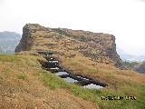 patch has to covered
with utter precaution as a single wrong move or lack of concentration
over the steps can end up one into the deep valley below on the left.
Very soon we cross the first entrance of the fort immediately followed
by the second and the final one. We finally made it to the top. The
view from here is simply splendid. On the left are the seven to eight
water cisterns in a row and onto the right is the spacious cave ideal
for night stay. Next to the cave on the right are another 3 water
cisterns out of which one holds clear portable water. The other two are
dry.
patch has to covered
with utter precaution as a single wrong move or lack of concentration
over the steps can end up one into the deep valley below on the left.
Very soon we cross the first entrance of the fort immediately followed
by the second and the final one. We finally made it to the top. The
view from here is simply splendid. On the left are the seven to eight
water cisterns in a row and onto the right is the spacious cave ideal
for night stay. Next to the cave on the right are another 3 water
cisterns out of which one holds clear portable water. The other two are
dry.